In detail ...
We awoke to thick cloud and cool temperatures; had the weather turned for the worst? We might have continued to doubt but for the assurance that the barometer gave; 14mB rise in the last three days. Setting out along the village road we discovered the Swiss camping by the garage-shop; they had arrived the night before. Back at Col d'Ibardin, they had been struck with some very bad luck indeed; a boot sole had come unstuck and consumed most of the day to fix. We greeted them and made good our lead; 'got to keep the competition at bay!' It was hard work getting out of the valley, especially as we had just taken on supplies for the next three days; fresh bread bought that morning, rice, sardines, tapioca, prunes, and by some gross miscalculation, two large potatoes. My pack weighed nearly 18kg, Karen's about 13kg.
200m of climbing and my hunch was proved correct as we climbed out of the mist into early sunlight; valley inversion cloud is more common when the atmospheric pressure is high.
Voici!
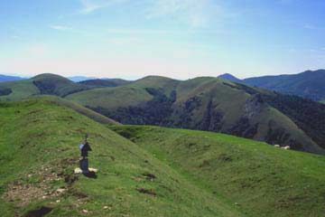
Our way was suppposed to lead towards Otzamunho (901m) without mounting it, but we missed the southwest bypass, lured on by the yellow
balisage which took us to the north. After 600m from the valley floor it was then little extra effort to take in the peak. A grassy descent took us steeply down to coralled flocks in the col Meharroztagiko Lepoa (738m), then we remounted to walk the broad ridge in and out of the beech woods.
Many of the big trees held a pigeon-shooters hide in their crown. It was in looking up at these that we noticed the vultures, first putting in a big appearance during the trek. They awaited better thermals which would lift them to dizzy heights, but in the meantime were confined to 'scratch' the tree canopy, affording us excellent sightings as they circled patiently. From there the way led pleasantly to a small col just before the Lindux, where we were grateful to find a captive water source and tap. Our breakfast of dry bread and prunes had left us thirsty. We rested there as a group of horse-riders passed through noisily; their leader was loud and expressive in his efforts to sustain group morale. It was quieter up at the Roman fort; little more than a square earthworks now, but with fine views in all directions.
Back into the beechwoods and sometimes on tarmac, I experienced severe shoulder pain as the pack straps knifed in; this often seemed to happen the worst in descent, especially long slow ones. Arriving at Puerto d'Ibaneta (1056m) we were startled to find
du monde; a major road crosses the Pyrenees here and gives access to all. Further, walkers on the GR65 pass through, many of them supported by vehicles carrying their packs,
groan. We had wondered about the possibility to end our day here, perhaps even at Roncevalles but enthusisam now ebbed fast and despite my shoulder stress, I rallied Karen to continue.
The Chough
French: 'Crave a bec rouge'. This bird is common in the mountain forest stage of the Pyrenees where crags provide nest and roosting sites. It is about the same size as a jackdaw with which it often mixes, but a curved red beak and red legs distinguish it from the former and also from the Alpine Chough which has a yellow beak. Its onomatopoeic name is the clue to its cheerful call which is often heard as it browses grasslands in flocks, or wheels and dives in aerobatic flight.
Steep grassy zig-zags carried us upwards, avoiding an obvious tarmac alternative where
les troupeaux marched. It took considerable effort to attain the heights of the mountain Mendi Chipi (1520m), whose name means 'small hill' in the ancient Euzkarien; seemed
damn big to me! We were a little concerned about an undocumented map transition here-abouts, but it was really only necessary to spot the GR65 walkers and proceed past them. High beech woods (1300m) shrouded the track on the north slopes before the GR11 parted company from GR65 at Col Bentarte (1337m) and took a slow descent into Spain. The open pastures which followed attracted choughs probing the cropped grass with slender curved beaks; perhaps they also sipped at the wayside spring which allowed us to refill our bottles.
Debate followed over several campsites now, but stamina held, and we reached Col Arnosteguy (1236m) below the limestone escarpments of Urkulu mountain. I could barely wait to cast off oppressive boots and there was plenty of space to camp here, but gallivanting horses made us a little nervous so we dragged another weary 500m to a flat topped spur on the south side.
Karen_comments
There, tired feet finally relaxed into open sandles and we pitched just off the route of the careless horses, in company of the poised megaliths of
dolmens and
cromlechs dating back to the Bronze age. The Basque region is rich in these relics and given more time and energy we should have taken time to inspect the notable
dolmen of 17m span which stands just above the col. As it was, the late sun barely gave us time to pitch and prepare supper before it sank from view and a chill wind chased us into our sleeping bags.