In detail ...
Should we have been concerned for the fall in pressure, 4mB overnight? The sky was clear except for some broken low cumulus, and our French companion at Ref Siscaro had told us the next front was not due until the Thursday (tomorrow). A sense of urgency pushed us on; the approaching front could drop fresh snow all over Carlit, making it truly
infranchissable. We were up at 7:30am after dreamy sleep, paid up to our hostess (less stressed today) and set out within the hour. Direction was good, but try as might, we missed the start of a
sentier which would have relieved us of ½hr of tarmac tedium. It should have set out directly by the hairpin of the N20.
The Bank Vole (from S18)
French: Campagnol Roussatre. Several species of vole live in the mountains at altitudes up to 2300m, but this species favours open woodlands. Along with the sharp-nosed
mulot (fieldmouse) it is one of the micro-mammals quintessential to the biosphere of the sub-alpine stage. The Common Vole and cousins favour open pastures where they feed on the tubercule-root of the white umbellifer 'pignut' (also good for human consumption). The Bank Vole depends on the seeds of the
pin a crochet ; it aids that tree by spreading fungi which develops beneficial mycchorizal relationships through the roots. Prolific reproduction of all voles loads the food chain for foxes, raptors, owls, snakes, martins and polecats.
The track brought us to a small carpark and noticeboard defining route options, from where a short steep ascent gained the easier hillside path we should already have been on. Two lightly clad walkers were en-route ahead of us and Karen pursued them while I took it easy for a while. The fall did not seem to be quite so advanced in this valley, but a range of tan and ochre in oak and birch framed the little reservoir below. Attention transferred ahead to another lake, the Estany de Font Viva set deep in rocky bowl beneath; it seemed not to have an outlet. Horses grazed at the eastern end, the early sun casting their long shadows towards the shimmering windlines on the water and blanching all to a golden monochrome.
Thus absorbed in meditative frame, it only dawned on me slowly that I was not catching up with Karen,
she remained ahead. 'No worries' I thought, stepping up pace, 'I must have been dawdling'. The path was easy but eroded and I could see her ahead, but a long way. The rocks had been disfigured with the untidy red painting of the letter 'R'
en majuscule, splashed onto every prominent and amenable boulder.
Not a
balisage I later discovered, but a shorthand for
chasse Reservé which protects the stout-horned
mouflon. This is an ancient sheep breed once confined to Corsica and Sardinia; it has been re-introduced to several parts of the Pyrenees, but only flourishes in the environs of Mt Carlit.
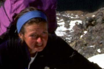
I was finally catching up with Karen, but only because she was waiting for me; I arrived straining and breathless. 'Do you want breakfast yet?' she inquired. No longer a routine question to my mind, what she really asked was
Are you short of energy today or what? Something had changed, me or her? Then I remembered her course of vitamin C supplements which the in-laws had delivered.
'No' I replied, 'Just give me some of your vitamin C,
Gingerbread woman! She glowed in my new found respect and we resumed the march with co-operative enthusiasm, quickly agreeing to hold out for a breakfast up by the dam. This was only the first of several occasions she was to surprise me in this stage.
Karen_comments
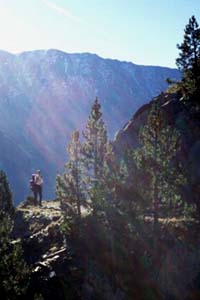
The path gained definition as it joined the track of an old mine extraction railway, a groove hewn from the steep rock massif on level traverse which offered superb views down onto the valley woods and ahead towards the dam. This pleasing
balcon led us past a number of darkly beckoning mine galleries, along with discarded cogs and cables, then also the rusted pylons of a
telepherique system. While much human impact on the landscape only jars and disturbs, we were grateful for these remnants and the airy track, which led us with absorbing speculation in a position otherwise unattainable.
Now approaching the dam, the
real HRP joined from the left; looking back along this, I saw that it had already climbed in crossing a small pass, and was relieved to realise we had not added an extra 250m to our stage with the diversion via the Porte. We turned eastwards and found a sunny breakfast spot near a small
cabane, sadly spoiled with accumulated refuse; obviously no helicopter service here! We turned our backs to this despoil, looking out over the lake, and on to Mt Carlit, which now stood clearly and awsomely defined; how much snow to contend with? I had re-questioned Karen to translate (from the guidebook) any recorded difficulties on the peak, but there seemed to be little save for the note
il faut mettre un peu les mains which implied some scrambling.
The onward way followed streams out through scattered boulders and thinning pines, losing sight of our peak for a while, before regaining it near the Etang des Forats. 'Wow!', it reared ever more steeply presenting itself as no average trekking challenge and excited a jittering anticipation in us. We arrived at the base of the final steepening,
Voici!
and made ourselves fit for the adventure; nervous ablutions, a change of film and some extra clothes on. Notably, we also took our ice-axes in hand; perhaps the next few hours would prove them to be materially more than idle passengers.
The obvious trace led us up a broad gully by zig-zags, before the gradient destroyed all order of passage; two steps up, and one back on the sliding screes. The gully narrowed into a huge cleft and simultaneously, we were forced onto the snow. Fortunately, it had thawed just enough to allow kicked steps,
most of the time. The ice axes started to pay their way, and so long as one stayed on snow, a rhythm could be established;
plunge the shaft,
stamp left foot,
stamp right foot. On encountering icy conditions, we moved nearer the gully wall, using the 'would be' bergschrund along with rock holds.
Then a point of decision; we had so far followed definite traces of passage, and hoped that these would continue to aid us through-out the ascent, but intermittent footsteps in the snow now deserted us completely at a divide in the gully. left fork or R? We consulted Véron, but the text made no mention of the gully, let alone its divide; its next presented goal was to head towards a
petite col. The right fork of the gully appeared steeper, and the left led to what might be that
petite col, so we continued, embarking on terrain which was very nearly
infranchissable and entering into the most exciting mistake of the whole trek. The gully snow held us in tempo for many minutes (plunge, stamp, stamp ...) before releasing us out onto a rocky shoulder.
Voici!
This commanding position offered sweeping views back to the big lake and its dam,
Voici!
rocky hillscapes dappled with snowfields and the blue sky with occasional whispy cumulus passing; were we ever so glad that the weather was clement! We 'set to' with the 'bit of scrambling' which remained, to realise just how fore-shortened the view had been from below.
Voici!
Here, the terrain encouaged no friendly rhythm as we transferred delicately from dry rough rocks to icy crust, then to plunging knee deep and back to the rocks again. What especially riveted attention was that much of the fickle gneiss was not well attached; great loose slabs poised over yawning precipices, which threatened to
schuss them and us into eternity.
Quarter of an hour later, our 'bit of scrambling' brought us to a false summit and an icy notch; then the difficulties resumed. As a moderately experienced mountaineer, I was getting quite enough excitement from this outing, but how was it for Karen? Quiet now were her supplications for well-trodden paths on secure ground. It is true that she would never have chosen such difficulties, but on finding them inescapeable, she bent to the challenge with a will. The trials of experience had at last created a foundation for dynamic interaction and her mind was steeled with resolve to cope with the present;
whatever it takes. I guided her continually, a handhold here, a step there, sometimes offering a pull to counterbalance the heavy rucsac.
Karen_comments
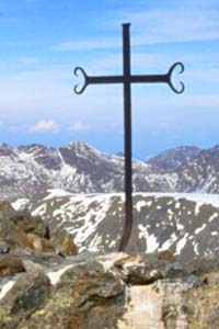
Slowly, the angle relented and we finally scrambled towards the
real col of Véron's description, and a view down onto the passage from the right gully fork, confirming our mistake. Relief flooded in joyfully as we worked the final icy rocks to gain the summit with its 360° panoramic views. Time to inspect the iron cross, the little red letterbox, and take obligatory snaps; the camera functioned perfectly after my attentions. To the east, we noted the string of lakes leading out through rugged country to our destination at Barrage Bouillouses.
Voici!
What would it take to arrive there? The whispy cumulus were now over-shadowed by approaching frontal cloud and the thought of advancing rain unsettled us.
The time was 3pm so we had ample daylight, but the further concern was for the hardening snow in the east facing descent gully, now plunged into shade. Even if the way were apparent, it was clearly going to absorb some time in passage. We set out, reversing the rocks to the col, then following serendipitous footsteps once more. At first, we faced out, then sideways on, before the steepening
couloir forced us to pay full attention. I went first, improving steps and creating new ones, while Karen faithfully followed instructions. The snow was crisp as expected and we were often forced to use melt cracks at the rock interface, which also offered re-assuring handholds from time to time.
Karen_comments
Slowly and steadily we worked our way down until it was possible to face out once more and there we encountered softer snow. This was a mixed blessing, allowing us to stamp good footholds, but sometimes sinking us into thigh deep buckets, which filled our boots with an unwelcome delivery of slush. It was quite inescapable, and we waded through, drawn on by the promise of bare ground
en contrebas. By the time we reached this, our feet were cold and sodden, so we stopped to wring socks. Karen remained cheerful and energetic and I reflected on her adaptability; she had coped so well with our impromptu wintry epic, that I pronounced her to be a
vrai montagnard.
The strato-cumulus was thickening, the wind strengthening, and the sun was sinking down behind the peak; only a brisk march could save us from this engulfing chill. At least now, a broad track led us on past the lakes, Estanys Sobira, Trebens, Llong, Llat, Comassa and Negre to our left and the expansive brown desert plateau on our right. Granite domes and cliffs framed all, with assorted boulders scattered liberally through-out. The spruce and pine trees returned, sheltering us progressively from the wind, and we warmed up to quit our worrying for a while.
It did seem a long way though, and we paused to consider the security of a green
abri, one of several by the route; if the rain were to strike right then, we could always scurry into that for the night. We had thought of investigating the refuge at the far side of the
barrage, but had no knowledge of winter quarters there, and knew the main building would be closed. On the other hand, we could just camp somewhere, anywhere, here and now; we considered many a site. Really, we preferred to reach our day's objective, the
barrage. 'Just a little further ...'.
The path entered devious
mamelon country, and we lost true sense of direction. Then it divided, and now with our view of the great lake blocked by the forest, we quickly lost ourselves amongst the trees. This happened familiarly at the point when it didn't seem worthwile re-tracing steps, so we employed the compass to seek a way forward. It was
so quiet here, and later research confirmed the present hunch;
bear country! The French literature loves to remind the reader that a bear is a
plantigrade, which is to say, a creature (in common with humans) which can stand on the soles of its feet. It was not hard to imagine one now looming through the dense pine brash, drawn up to its full 2m height. We pushed on through the trees, detoured around boulders and hummocks, and cursed our haste after losing all trace of passage; surely we had been closer to the dam than this diversion suggested?
When we finally caught a glimpse of the water ahead, we began to relax and declared that the next suitable campsite would be sufficient. A trace of passage brought us into a grassy ravine dwarfed by its wooded hummocks and there we found broken meadows by a small stream; seclusion enough and hopefully just near enough to human habitation to keep the bears at a distance! I pitched while Karen prepared some food, and having finally removed wet boots, we lay prone to eat dinner peaking out from the tent's entrance. The evening was by now dusky but a waxing half moon illumined us from just over the pine-tops. It was paled by the frontal cloud, and the ragged cumulus blowing past, but it blessed our little meal with its magical glow and sent us to a contented rest.